
A height map is a grayscale picture of the ground: black is low, white is high. Traxx can now read one in to replace your terrain, write your terrain out as one, and lift or scale every height at once. That opens the door to ground made in a terrain generator, or touched up in a paint program.
You do not need this page to build a track. It is for when you want ground from somewhere else, or want to carry your own ground out of Traxx and back.
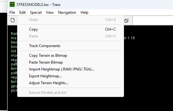
Choose Edit → Import Heightmap (.RAW/.PNG/.TGA)... and pick the file. The file window's title reminds you that a 16-bit .RAW is little-endian ("IBM PC" byte order in Photoshop's Raw window), with the rows running top to bottom.
What Traxx takes:
The size must be 256 x 256 (the usual 32 ft grid) or 1024 x 1024 (one point every 8 ft). Anything else is refused, with the sizes it does take, and the track is left as it was. If your generator wrote a 1025 x 1025 map, the message tells you to drop the last row and column.
The top row of the picture is the map's first row (Z 0).
Traxx asks before it changes the grid the track is on:
Note: an image that is not a plain grayscale is turned away with its reason — a colour PNG, a 4-bit PNG, a colour TGA, a TGA that is stored right to left (flip it and save it again). An 8-bit 1024 map is accepted, but Traxx tells you the Full Map will have 2 ft steps; export it as 16-bit from your generator for smooth ground.
Note: lakes are checked after an import. If the new ground would break one, the import is cancelled with a warning naming the lake (see Lakes). Where an import cannot be undone, Traxx does not cancel it — it warns that the new heights leave a lake in error, and you fix the lake.
Edit → Export Heightmap... writes your terrain out. The file window offers three types:
A Classic 8-bit track is offered the 8-bit PNG first; every other grid is offered the 16-bit PNG. The name offered is the track's, with .png on the end. If you type an extension, that decides the format; if you type none, the type you picked does, and Traxx adds its extension and asks before it replaces an existing file.
A Full Map is written at 1024 x 1024; the other grids at 256 x 256. Export, edit the picture anywhere, import it back — the heights come back as they went out.
When you write the pod, the ground travels as a height file. Special → Terrain Grid → Store heights as PNG makes it a grayscale PNG instead (16-bit, or 8-bit on a Classic 8-bit track). The entry gets a tick, the setting is saved with your track, and the heights themselves do not change.
On a Classic 8-bit track the pod carries the old .RAW beside the PNG, so the track still runs everywhere, the original game included. The entry is greyed when you are only viewing a pod.
Edit → Adjust Terrain Heights... lifts or scales the whole terrain at once. (The same command is Adjust Heights... on the right-click menu in Edit Terrain mode.) It works on every grid.
The Adjust Terrain Heights window has two ways to change the ground:
Under Terrain heights the window shows the lowest and highest heights Now and After, live as you type. Heights run from 0 to 255; anything pushed past either end is clipped to it.
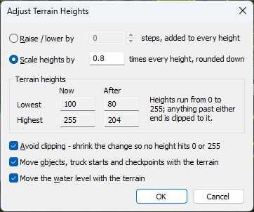
Three tickboxes sit underneath, all ticked to begin with:
Lakes always move with the ground, whatever that last box says. But a lake can never be left leaking: if the adjustment would breach one, the whole adjustment is cancelled with a warning that names the lake, and nothing changes. Edit → Undo puts back everything the window changed — terrain, objects, water.
See also: Terrain Bitmap, Altitudes.
| << Smoother Ground << | >> Water >> |
